


LET EVERYONE YOU KNOW WHO LIVES ON THE WEST COAST SO THEY CAN BE PREPARED AND PRAY 
70 Comments
This web site was among the very first to begin warning folks in Hawaii and on the west coast of North America, that a portion of Hawaii's southern coastline, was in danger of collapsing into the ocean from the ongoing eruption of the Kilauea volcano. If such a collapse took place, it would cause a Pacific-wide TSUNAMI, with waves of 99 feet tall possibly plowing into San Diego, Los Angeles, San Francisco and Vancouver, British Columbia CANADA, four to five hours after such a collapse takes place.
I was sharply ridiculed as a "fear-monger" and accused of "publishing nonsense." I was told my reports were "fake news" and they were designed to be "click bait." Well . . . guess what the Hawaii Volcano Observatory said about a Sea Cliff near Kilauea the last time large lava was spewing out as it is now. Feast your eyes on this:
Kilauea Volcano's: "Lava flow is still active and entering the ocean at Kamokuna on the volcano's south coast. Recent observations of the ocean entry indicate growing instability of the adjacent sea cliff. A potential collapse of the cliff poses an extreme danger to anyone in the closed area on land, as well as to boats near the ocean entry. . .
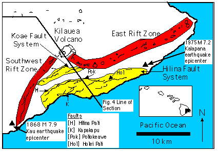
The name of the unstable land mass on Kilauea's seaward side is the "Hilina Slump."
In the graphic below, the area in Yellow constitutes the Hilina Slump:
In a companion feature in the Feb. 28 issue of Nature, research geophysicist Steven N. Ward of the University of California-Santa Cruz estimated Kilauea's southern flank to be nearly equal in size to a half-mile-thick slice of Rhode Island. If that massive chunk of land suddenly collapsed into the ocean . . . it could generate an enormous wall of seawater -- or tsunami -- powerful enough to threaten coastal cities as far away as California, Chile and Australia, according to Ward.
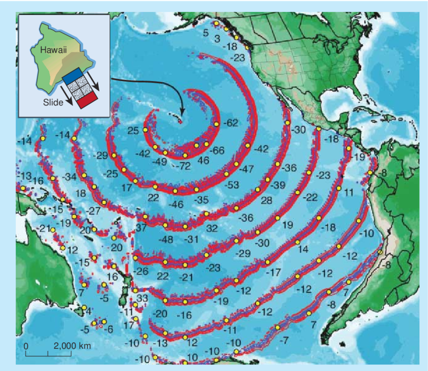
Below is a graphic from a computer simulation showing wave heights - in METERS - in two hour intervals after such a collapse takes place. Please note that in the first circle, wave heights coming at the west coast of the United States are simulated at 62 METERS in height. That's two hundred and three FEET tall, traveling toward the US west coast at about five hundred miles per hour.
In the second ring, at four hours, the simulation shows the approaching waves to be down to 42 METERS. That's 138 FEET tall.
By the time the third ring begins smashing onto the west coast of North America, wave heights are somewhere between 42 and 30 METERS. That means a wave of water AT LEAST NINETY EIGHT FEET TALL smashing into San Diego, Los Angeles and other places on the west coast.

Do you have any idea at all of the absolute destruction that would take place if a 98 feet tall wave slammed into San Diego, Los Angeles, San Francisco and Vancouver? The cities would be obliterated. Skyscrapers would be knocked over like toothpicks. Homes would be knocked off their foundations and collapse. NOWHERE would be safe unless people were farther inland than the water can travel.
50 miles inland would be a very safe distance.
Don't panic, PLAN!
Bear in mind, THIS MAY NOT TAKE PLACE. The volcano might stop erupting and all might be well.
HOWEVER . . . . prudence dictates that we be rational adults and keep aware of the potential danger from this ongoing situation.
To that end, I implore you: Keep close watch on developments with the Hawaii eruption. IF YOU HEAR WORD THAT A SEA CLIFF COLLAPSE HAS OCCURRED, EVACUATE. Don't wait.
The longer you wait, the more people are going to find out what's taking place. PANIC will set in. Think about it: there are 10 million people in Los Angeles, 1.4 million in San Diego, 865,000 in San Francisco and 2.4 MILLION in Vancouver. They would have four hours to escape to 50 miles inland or be killed. If you wait, more and more of those millions of people will have already started fleeing -- and maybe panicking. The longer you wait, the more traffic and panicked people you'll have to deal with.
So keep alert, monitor the situation and have a plan for you and your family. If a collapse takes place, know in advance where you're going and how you're getting there.
PLEASE PASS THIS ALONG TO ANYONE YOU KNOW WHO LIVES IN CALIFORNIA, OREGON, WASHINGTON state or VANCOUVER. The mass-media is not reporting this for fear of "scaring people" but the general public HAS TO KNOW. You telling them might save their lives! Think about this for a second: YOU . . . . . right now . . . . . have a chance to maybe save someone's life. Just by passing along some info. "Hey so and so, did you hear about that volcano in Hawaii? (Yea) Well today they're warning that a big chunk of the volcano might fall off into the ocean causing a Tsunami that might hit where WE/YOU Live with 98 foot waves! (WHOA! ) Yea, I'm going to send you a link to read about it. You should read it, it might save your life.
Here is a link to my original article which sounded the Warning back on May 6:
GOOD LUCK. STAY SAFE.
KILAUEA VOLCANO (VNUM #332010)
19°25'16" N 155°17'13" W, Summit Elevation 4091 ft (1247 m)
Current Volcano Alert Level: WARNING
Current Aviation Color Code: RED
,Kīlauea Volcano Summit
After the explosive eruption early this morning seismic levels have been gradually increasing, but as of this report no additional explosions have occurred.
No earthquakes greater than magnitude 3.5 have occurred in the past day.
Volcanic gas emissions at the summit remain high.
Kīlauea Lower East Rift Zone
This afternoon, fissure 17 is still actively spattering but the flow is nearly stalled. In addition, fissures 18, 19, and 20 have reactivated and a new fissure (21) has opened between fissures 7 and 3. An area 50-100 yards wide, parallel to and north of the line of fissures between Highway 130 and Lanipuna Gardens, has dropped slightly. This long depression is currently being filled by pahoehoe lava flows from fissures 20 and 21.
Volcanic gas emissions remain elevated throughout the area downwind of the fissures.
Magma continues to be supplied to the lower East Rift Zone as indicated by the continued northwest displacement of a GPS monitoring station. Elevated earthquake activity continues, but earthquake locations have not moved farther downrift in the past couple of days.
USGS/HVO continues to monitor the lower East Rift Zone activity 24/7 in coordination with Hawaii County Civil Defense, with geologists onsite to track ongoing and new fissure activity and the advance of lava flows.
MORE INFORMATION
Activity Summary also available by phone: (808) 967-8862
Subscribe to these messages: https://volcanoes.usgs.gov/vns2/
Webcam images: https://volcanoes.usgs.gov/volcanoes/kilauea/multimedia_webcams.html
Photos/Video: https://volcanoes.usgs.gov/volcanoes/kilauea/multimedia_chronology.html
Lava Flow Maps: https://volcanoes.usgs.gov/volcanoes/kilauea/multimedia_maps.html
Definitions of terms used in update: https://volcanoes.usgs.gov/volcanoes/kilauea/extra/definitions.pdf
Overview of Kīlauea summit (Halemaʻumaʻu) and East Rift Zone (Puʻu ʻŌʻō ) eruptions:
https://volcanoes.usgs.gov/volcanoes/kilauea/extra/background.pdf
Summary of volcanic hazards from Kīlauea eruptions:
https://volcanoes.usgs.gov/volcanoes/kilauea/extra/hazards.pdf
Recent Earthquakes in Hawai'i (map and list):
https://volcanoes.usgs.gov/hvo/earthquakes/
Explanation of Volcano Alert Levels and Aviation Color Codes:
https://volcanoes.usgs.gov/activity/alertsystem/index.php
https://pubs.usgs.gov/fs/2006/3139/
CONTACT INFORMATION:
askHVO@usgs.gov
The Hawaiian Volcano Observatory is one of five volcano observatories within the U.S. Geological Survey and is responsible for monitoring volcanoes and earthquakes in Hawai`i.
http://halturnerradioshow.com/index.php/news/world-news/2542-hawaii-finally-admitting-sea-cliff-collapse-danger-tsunami-danger
Hawaii FINALLY Admits: "Sea Cliff Collapse" Danger ---- TSUNAMI Danger for San Diego, Los Angeles, San Francisco and Vancouver, BC
Category: World News Thursday, 17 May 2018 20:26 70 Comments
This web site was among the very first to begin warning folks in Hawaii and on the west coast of North America, that a portion of Hawaii's southern coastline, was in danger of collapsing into the ocean from the ongoing eruption of the Kilauea volcano. If such a collapse took place, it would cause a Pacific-wide TSUNAMI, with waves of 99 feet tall possibly plowing into San Diego, Los Angeles, San Francisco and Vancouver, British Columbia CANADA, four to five hours after such a collapse takes place.
I was sharply ridiculed as a "fear-monger" and accused of "publishing nonsense." I was told my reports were "fake news" and they were designed to be "click bait." Well . . . guess what the Hawaii Volcano Observatory said about a Sea Cliff near Kilauea the last time large lava was spewing out as it is now. Feast your eyes on this:
Kilauea Volcano's: "Lava flow is still active and entering the ocean at Kamokuna on the volcano's south coast. Recent observations of the ocean entry indicate growing instability of the adjacent sea cliff. A potential collapse of the cliff poses an extreme danger to anyone in the closed area on land, as well as to boats near the ocean entry. . .
The name of the unstable land mass on Kilauea's seaward side is the "Hilina Slump."
In the graphic below, the area in Yellow constitutes the Hilina Slump:
In a companion feature in the Feb. 28 issue of Nature, research geophysicist Steven N. Ward of the University of California-Santa Cruz estimated Kilauea's southern flank to be nearly equal in size to a half-mile-thick slice of Rhode Island. If that massive chunk of land suddenly collapsed into the ocean . . . it could generate an enormous wall of seawater -- or tsunami -- powerful enough to threaten coastal cities as far away as California, Chile and Australia, according to Ward.
A catastrophic flank collapse of an oceanic volcano happens somewhere in the world every 10,000 years on average, Ward added, but none has been caught in its early stages until now.
Below is a graphic from a computer simulation showing wave heights - in METERS - in two hour intervals after such a collapse takes place. Please note that in the first circle, wave heights coming at the west coast of the United States are simulated at 62 METERS in height. That's two hundred and three FEET tall, traveling toward the US west coast at about five hundred miles per hour.
In the second ring, at four hours, the simulation shows the approaching waves to be down to 42 METERS. That's 138 FEET tall.
By the time the third ring begins smashing onto the west coast of North America, wave heights are somewhere between 42 and 30 METERS. That means a wave of water AT LEAST NINETY EIGHT FEET TALL smashing into San Diego, Los Angeles and other places on the west coast.
Do you have any idea at all of the absolute destruction that would take place if a 98 feet tall wave slammed into San Diego, Los Angeles, San Francisco and Vancouver? The cities would be obliterated. Skyscrapers would be knocked over like toothpicks. Homes would be knocked off their foundations and collapse. NOWHERE would be safe unless people were farther inland than the water can travel.
50 miles inland would be a very safe distance.
DON'T PANIC --- PLAN
It is important for me to reiterate that the purpose of this report and the ones which preceded it, is to ALERT YOU to the POTENTIAL danger, so you HAVE A PLAN.Don't panic, PLAN!
Bear in mind, THIS MAY NOT TAKE PLACE. The volcano might stop erupting and all might be well.
HOWEVER . . . . prudence dictates that we be rational adults and keep aware of the potential danger from this ongoing situation.
To that end, I implore you: Keep close watch on developments with the Hawaii eruption. IF YOU HEAR WORD THAT A SEA CLIFF COLLAPSE HAS OCCURRED, EVACUATE. Don't wait.
The longer you wait, the more people are going to find out what's taking place. PANIC will set in. Think about it: there are 10 million people in Los Angeles, 1.4 million in San Diego, 865,000 in San Francisco and 2.4 MILLION in Vancouver. They would have four hours to escape to 50 miles inland or be killed. If you wait, more and more of those millions of people will have already started fleeing -- and maybe panicking. The longer you wait, the more traffic and panicked people you'll have to deal with.
So keep alert, monitor the situation and have a plan for you and your family. If a collapse takes place, know in advance where you're going and how you're getting there.
PLEASE PASS THIS ALONG TO ANYONE YOU KNOW WHO LIVES IN CALIFORNIA, OREGON, WASHINGTON state or VANCOUVER. The mass-media is not reporting this for fear of "scaring people" but the general public HAS TO KNOW. You telling them might save their lives! Think about this for a second: YOU . . . . . right now . . . . . have a chance to maybe save someone's life. Just by passing along some info. "Hey so and so, did you hear about that volcano in Hawaii? (Yea) Well today they're warning that a big chunk of the volcano might fall off into the ocean causing a Tsunami that might hit where WE/YOU Live with 98 foot waves! (WHOA! ) Yea, I'm going to send you a link to read about it. You should read it, it might save your life.
Here is a link to my original article which sounded the Warning back on May 6:
FEARS OF TSUNAMI FOR U.S. WEST COAST AS ERUPTING HAWAII VOLCANO FRACTURES MASSIVE UNSTABLE LANDMASS
In the meantime, I recommend you gas-up your car(s)/truck(s) and keep a full tank. No one knows IF this is going to take place and no one knows WHEN this is going to take place. You don't want to get rousted out of bed in the middle of the night being told to flee for your life, and find out you've got no gas in the car. Throw a bag with some snacks and water in the back too, so you and your family can munch while you're evacuating. Being prepared is simple, if you take a minute to do it in advance. If you wait until all hell breaks loose, things will not go well.GOOD LUCK. STAY SAFE.
UPDATE 11:47 PM EDT --
Here is the latest Report from the Hawaii Volcano Observatory:HAWAIIAN VOLCANO OBSERVATORY STATUS REPORT
U.S. Geological Survey
Thursday, May 17, 2018, 4:54 PM HST (Friday, May 18, 2018, 02:54 UTC)
U.S. Geological Survey
Thursday, May 17, 2018, 4:54 PM HST (Friday, May 18, 2018, 02:54 UTC)
KILAUEA VOLCANO (VNUM #332010)
19°25'16" N 155°17'13" W, Summit Elevation 4091 ft (1247 m)
Current Volcano Alert Level: WARNING
Current Aviation Color Code: RED
,Kīlauea Volcano Summit
After the explosive eruption early this morning seismic levels have been gradually increasing, but as of this report no additional explosions have occurred.
No earthquakes greater than magnitude 3.5 have occurred in the past day.
Volcanic gas emissions at the summit remain high.
Kīlauea Lower East Rift Zone
This afternoon, fissure 17 is still actively spattering but the flow is nearly stalled. In addition, fissures 18, 19, and 20 have reactivated and a new fissure (21) has opened between fissures 7 and 3. An area 50-100 yards wide, parallel to and north of the line of fissures between Highway 130 and Lanipuna Gardens, has dropped slightly. This long depression is currently being filled by pahoehoe lava flows from fissures 20 and 21.
Volcanic gas emissions remain elevated throughout the area downwind of the fissures.
Magma continues to be supplied to the lower East Rift Zone as indicated by the continued northwest displacement of a GPS monitoring station. Elevated earthquake activity continues, but earthquake locations have not moved farther downrift in the past couple of days.
USGS/HVO continues to monitor the lower East Rift Zone activity 24/7 in coordination with Hawaii County Civil Defense, with geologists onsite to track ongoing and new fissure activity and the advance of lava flows.
MORE INFORMATION
Activity Summary also available by phone: (808) 967-8862
Subscribe to these messages: https://volcanoes.usgs.gov/vns2/
Webcam images: https://volcanoes.usgs.gov/volcanoes/kilauea/multimedia_webcams.html
Photos/Video: https://volcanoes.usgs.gov/volcanoes/kilauea/multimedia_chronology.html
Lava Flow Maps: https://volcanoes.usgs.gov/volcanoes/kilauea/multimedia_maps.html
Definitions of terms used in update: https://volcanoes.usgs.gov/volcanoes/kilauea/extra/definitions.pdf
Overview of Kīlauea summit (Halemaʻumaʻu) and East Rift Zone (Puʻu ʻŌʻō ) eruptions:
https://volcanoes.usgs.gov/volcanoes/kilauea/extra/background.pdf
Summary of volcanic hazards from Kīlauea eruptions:
https://volcanoes.usgs.gov/volcanoes/kilauea/extra/hazards.pdf
Recent Earthquakes in Hawai'i (map and list):
https://volcanoes.usgs.gov/hvo/earthquakes/
Explanation of Volcano Alert Levels and Aviation Color Codes:
https://volcanoes.usgs.gov/activity/alertsystem/index.php
https://pubs.usgs.gov/fs/2006/3139/
CONTACT INFORMATION:
askHVO@usgs.gov
The Hawaiian Volcano Observatory is one of five volcano observatories within the U.S. Geological Survey and is responsible for monitoring volcanoes and earthquakes in Hawai`i.
http://halturnerradioshow.com/index.php/news/world-news/2542-hawaii-finally-admitting-sea-cliff-collapse-danger-tsunami-danger

» utube 11/21/24 MM&C MM&C News Reporting-Global Trade-Best Route in World-Purchase Power-Justice-Cen
» Koger: The budget schedules have not reached us yet, and we will start the sessions as soon as they
» MP calls for activating China's Belt and Road Initiative economy
» Al-Baldawi: Political will controls the fate of the ministerial amendment
» Al-Lami: US bases in Iraq represent a military arsenal to protect the entity
» Iraq sends "identical" messages to international and Arab parties regarding Israeli threats
» Iraqi parliament resumes sessions on Monday with 'important' laws
» The Central Bank of Iraq sells more than $894 million in three days
» With the participation of the private sector.. Iraq studies a project to establish a large medical c
» OPEC Secretary General: Crude Oil and Natural Gas are 'Gifts from God'
» How much did the census cost in Iraq?
» Türkiye hints at “good news” regarding Kurdistan oil exports.. What about the development path?
» Minister of Education: Project No. 1 has reached its final stages and new schools will be announced
» With Al-Mashhadani's support... Parliamentary move to activate the oversight role during the upcomin
» Israel sends messages to Iraq: An expected strike and no options for deterrence
» A government bank in Karbala embezzles installment amounts paid by a number of borrowers
» Iraqi government begins measures to prevent oil “smuggling” from Kurdistan
» Iraq sends "identical" messages to international and Arab parties regarding Israeli threats
» Al-Araji: The international coalition has great credit in helping Iraq defeat ISIS
» Dollar price stability in Iraq
» Trade announces a special application for the ration card that determines the mechanism for families
» Iraqi exhibitions participate in the UFI conference in Germany
» Industry: A plan to increase battery production and cover the needs of the local market
» Health: We are studying the establishment of medical cities in Baghdad and the governorates with the
» Foreign Minister: The government has taken internal and external steps regarding the threats of the
» Immigration: Report to be submitted next month to curb illegal immigration
» The Arab League will hold a meeting next Sunday to confront the threats of the Zionist entity, at th
» Iraq comments on the threats of the Zionist entity
» Al-Mandlawi: The International Court’s decision to arrest Netanyahu and his defense minister is a st
» Supreme Census Authority: End of the second phase of the population census
» An inside look at Iraq’s “fuel smuggling market”: New developments and smugglers “suffering”
» Find out the dollar exchange rates in the Iraqi stock exchanges
» New embezzlement operations revealed in a government bank in Karbala
» Officially.. The Supreme Authority for Population Census sets the date for announcing the results
» Prime Minister: It is hoped that the remaining 1,000 schools will be completed within two months - U
» utube 11/19/24 MM&C Report-Census-Global Transparency-Budget-Trade-Banking-Delete the Ze
» Barzani: The relationship with Baghdad is good and no problem can be solved by force
» Al-Mashhadani: The international system today is “fluid and in crisis” and the Middle East crisis is
» Legal Center: Iraq is the fourth Arab country in child labor and there is a need to legislate a law
» Democratic: The new regional government is a coalition and one step away from negotiations to form i
» Parliament resumes its sessions next week... and clarification of the mechanism for extending its le
» A member of the Patriotic Union of Kurdistan stresses the need to pass the Kurdistan budget law, whi
» Framework warns: Agreement with Washington will be at stake if Iraq is bombed
» Protecting Iraq is an American duty: Security agreements are not just ink on paper
» Moderate leaders...are they able to guide the path at a regional crossroads?
» Politician reveals political agreements to vote on personal status law
» US report shows the importance of the population census in Iraq: It will reshape this map
» Dollar-Dinar Exchange Rate Gap: Causes and Treatments
» The Fifth Forum for Peace and Security in the Middle East kicks off in Dohuk with the participation
» Planning for / Nina /: The census results will be announced at this time and we implemented the proj
» Former MP: Worrying circumstances accompanied the population census process in Basra
» MP Hassan Al-Asadi brings good news to a group of those covered by Article 140
» Economist: Total cost of general population census reached 951 billion dinars
» Israel's complaint against Iraq.. a prelude to an expected military action - Urgent
» Mahmoud Al-Mashhadani: What is happening today in the Middle East is a “vital area for the second Na
» The complex of forming the regional government is exacerbated by the adherence to the “old faces”
» Bitcoin hits new record
» Prime Minister's Advisor: National Development Plan 2024-2028 depends on census results
» Al-Abadi responds to Senator Lindsey Graham's statement: Incites new conflicts and wars
» War developments portend danger in Iraq.. Israeli threatening messages arrived via a regional state
» Controversy over Kurdish citizens entering Kirkuk before the population census.. What's the story?
» MP reveals date of passing general amnesty and personal status laws
» Economist: The census will lead to an increase in the share of some governorates in regional develop
» Al-Sudani directs to equip border forces with modern weapons and secure all their requirements
» Iraqi government: We are making great efforts to control the influence of factions inside Iraq
» utube 11/18/24 US President Donald Trump Statement About Iraqi Dinar New RateIraqi Dinar News
» Mazhar Saleh: Population census is the basis for achieving optimal development
» Setting the date for announcing the preliminary results of the population census
» Kurdish MP: Population census will affect all governorates financially
» Between Israeli accusations and Baghdad's position: Is Iraq heading towards an international confron
» Al-Sudani renews his directives on the necessity of completing service projects within the previousl
» Political movement calls on parliament to strike dens of corruption
» MP criticizes the Foreign Ministry's performance towards the Turkish occupation
» Parliamentary Economy Committee criticizes the government’s withdrawal of the Public-Private Partner
» Before the vote... Washington moves its agendas to prevent the approval of the personal status law
» Al-Maliki: The Zionist entity seeks to strike Iraq through its expansionist war
» MP identifies 3 black images of the American role in the Middle East
» Where is the Baghdad-Washington agreement? The Zionist entity provokes Iraq and threatens to bomb it
» Durable goods are an open option for citizens.. Planning indicates a high response to the population
» Parliamentary Legal: The regional government is trying to change the demographics of Kirkuk to regai
» Arrest warrant issued for Anbar Council member for involvement in corruption and terrorism cases
» Al-Sudani directs continued payment of wages to workers on a "daily wage" during the two days of the
» What is the relationship between the population census and the national development plan? Al-Sudani’
» Iraq's seaborne crude oil exports decline
» Will the population increase the number of representatives in Iraq?
» In cooperation with the United Nations Population Fund.. The first population census in Iraq in more
» Jordanian company completes strategic submersible pumps project in Iraq
» Rasool: The government is pursuing anyone involved in activities that threaten Iraq's security
» US military creates air bridge from Iraq to Syria
» Al-Sudani, Putin discuss Middle East issues amid unprecedented escalation of tension in the region
» Know the secrets of the Iraqi house.. Baghdad demands that Washington deter Israel
» On the second day of the curfew, Al-Sudani tours Baghdad and “meets citizens”
» Planning: Slums are counted as a fact in the population census
» Despite problems, Iraq and Turkey agree to increase trade exchange
» Iraqi regions detect drones.. and Washington informs Baghdad of "exhausting" its pressure on the ent
» Bitcoin breaks $97,000 barrier for the first time in its history
» A difference of more than two million people: Iraqi or international estimates? Who will prove the a
» In numbers.. UAE exports to Iraq grow significantly