- Another weather bomb to relieve a crippling drought: Incredible amount of rain bringing sub-tropical drenching with heavy downpours to New Zealand
- Bird flu arrives in Tennessee: Tests confirmed the presence of the Highly Pathogenic Avian Influenza, or HPAI at a facility in Lincoln County
- A little later than expected but..A mag 6.5 strikes Papua New Guinea as massive coronal hole on the Sun begins to turn away from Earth
- Madagascar braces for life-threatening impacts from strengthening Tropical Cyclone Enawo less than a month after Tropical Cyclone Dineo caused havoc in the area
- 10 tons of dead fish suddenly surfaced in a 2 hour period in Zhejiang PuTuo China : Boat Captain "sea fishing for more than 30 years never seen such a thing"
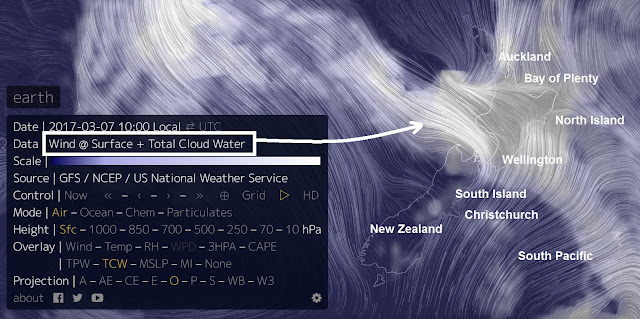
| Another weather bomb to relieve a crippling drought: Incredible amount of rain bringing sub-tropical drenching with heavy downpours to New Zealand Posted: 06 Mar 2017 02:05 AM PST Earthwindmap Click on image to enlarge.
The Bay of Plenty is being warned to brace for a sub-tropical drenching with heavy downpours so intense the crippling drought affecting parts of the North Island may be finally be broken. Heavy rain is expected to hit the country tomorrow and last for up to a week. This morning Metservice issued a severe weather watch for the Western Bay of Plenty and Rotorua, warning of heavy, possibly thundery, falls from late tomorrow until Thursday. At the same time the South Island is facing an autumnal cold snap with temperatures in some regions barely registering above single digits. MetService said a low pressure system was expected to stay at the top of the country dragging humid air down from the subtropics and bringing rain across northern regions. The downpours were expected be intense there was a possibility warnings would be issued for upper districts of the North Island. The rain was also expected to fall over Gisborne, the Hawkes Bay ranges, and the central North Island high country but not to warning levels. At this stage there was still some uncertainty about which areas would get the heaviest rain. Weatherwatch.co.nz said the rain would finally bring relief to farmers in Northland and Gisborne signalling an end to the drought. Meanwhile, temperatures in the far south had started plummeting with Dunedin and Invercargill reaching just 14C today and expected to be even cooler tomorrow. Weatherwatch.co.nz said Christchurch, which has a high in the mid-20s today, would feel a noticeable nip overnight plunging to 14C before bouncing back later this week. Home Page The Wire |
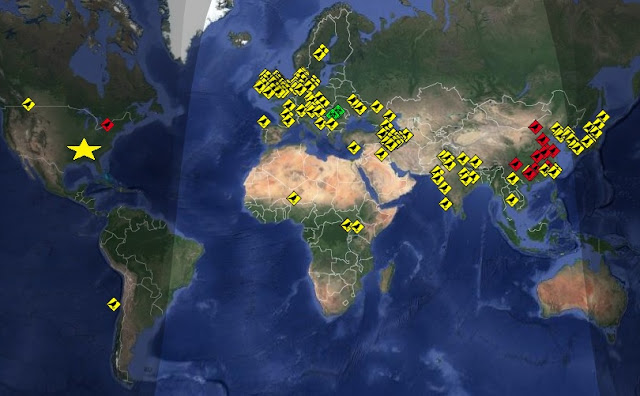
| Bird flu arrives in Tennessee: Tests confirmed the presence of the Highly Pathogenic Avian Influenza, or HPAI at a facility in Lincoln County Posted: 06 Mar 2017 01:30 AM PST Click on RSOE Alert map to enlarge, red squares indicate humans infected or dead Agriculture officials say a commercial chicken breeding facility in south-central Tennessee has been hit by a strain of bird flu. The state Agriculture Department says in a news release that tests confirmed the presence of the Highly Pathogenic Avian Influenza, or HPAI, at a facility in Lincoln County. The facility alerted the state veterinarian's office on Friday about an increase in chicken deaths. The statement did not name the facility. The facility and about 30 other poultry farms within about a six-mile radius of the site are under quarantine. Officials said HPAI poses no risk to the food supply, and no affected chickens entered the food chain. The statement says the most recent U.S. detection of HPAI was in January 2016 in a commercial turkey flock in Indiana. Home Page The Wire |
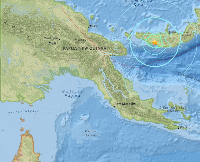
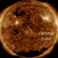
| A little later than expected but..A mag 6.5 strikes Papua New Guinea as massive coronal hole on the Sun begins to turn away from Earth Posted: 06 Mar 2017 01:09 AM PST USGS It was expected, it is even maybe a little late but a shallow magnitude 6.5 quake struck Papua New Guinea last night. Image..Earth is exiting a stream of solar wind flowing from the indicated coronal hole. Credit: NASA/SDO. There is No Tsunami Warning, Advisory, Watch, or Threat in effect. It was expected because a large coronal hole has been facing the earth for the last few days hurling solar wind at our magnetosphere at incredible speeds of over 700 km/second Coronal Holes are the primary earthquake factor. We are looking for the dark patches, which indicate that the interplanetary magnetic fields connecting earth to sun may be about to experience significant fluctuations of energy. Learn more about why coronal holes are important earthquake factors here, http://quakewatch.net/ The massive coronal hole is now turning away from Earth bringing a huge change in pressure on the Earths tectonic plates. Yesterday's major quake was the is the first of March and the 13th of 2017. Home The Wire |
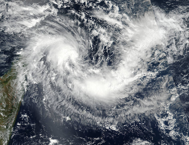
| Madagascar braces for life-threatening impacts from strengthening Tropical Cyclone Enawo less than a month after Tropical Cyclone Dineo caused havoc in the area Posted: 05 Mar 2017 07:55 AM PST This visible image of newly developed tropical cyclone Enawo was taken from the VIIRS instrument aboard NASA-NOAA's Suomi NPP satellite on March 3 at 0954 UTC (4:45 a.m. EST). The tropical storm formed northeast of the African island country of Madagascar. Credits: NOAA/NASA Goddard MODIS Rapid Response Team Enawo continues to strengthen into a dangerous tropical cyclone as it nears landfall in northern Madagascar, posing a risk to lives and property this week. As Enawo strengthens through the beginning of the week, Madagascar residents should make necessary precautions as impacts from the dangerous cyclone will begin to be felt as early as Monday in northeastern parts of the country. Enawo is currently as strong as a Category 1 hurricane in the Atlantic or eastern Pacific oceans. Rain, wind and seas will build around Enawo’s center as it intensifies, posing dangers to shipping interests. AccuWeather meteorologists expect additional strengthening as Enawo turns towards northeastern Madagascar early this week. Enawo is expected to strengthen into an intense tropical cyclone (the equivalent of a major hurricane) before making landfall on Monday night or Tuesday, local time. "It is becoming evident that northeastern Madagascar will experience increasing winds and heavy rainfall from Monday into Tuesday," AccuWeather Senior Meteorologist Jason Nicholls said. The worst impacts are expected to be felt from Tuesday into Wednesday, when landfall is expected. Home Page The Wire |
| 10 tons of dead fish suddenly surfaced in a 2 hour period in Zhejiang PuTuo China : Boat Captain "sea fishing for more than 30 years never seen such a thing" Posted: 05 Mar 2017 07:42 AM PST Fisherman said they caught nearly 10 tons of dead fish in a two hour period. Translated from Chinese Almost 10 tons of dead fish have suddenly surfaced in a 2 hour period on the afternoon of February 19th in Zhejiang PuTuo China Apparently two fishing boats were in operation when suddenly thousands of glistening yellow croaker floated to the surface. Swarms of them surfaced in the next 2 hours with the fishermen caught nearly 10 tons in total. According to the evening news reports in Zhoushan, Captain Zhang of one of the fishing boats claimed the boats where surrounded by a radius of nearly 100 meters of dead fish. The other fishing boat captain of Xia Guoping said, it felt incredible, he said he had been sea fishing for more than 30 years, and had never encountered such a thing. The fish are thought to have died from a toxic substance. Mass animal deaths Home Page The Wire |




» The Council of Ministers will suspend official working hours next Wednesday
» An almost complete outage of water and electricity in western Anbar
» Parliamentary expectations of extending the legislative term to approve the budget
» Education: The cost of participating in the electronic school will amount to 200 thousand dinars
» Al-Sudani arrives in Riyadh to participate in the World Economic Forum
» A newspaper reveals a dark world that brings together bloggers and politicians
» Al-Marsoumi: The bombing of the Kormor field undermined efforts to achieve self-sufficiency in gas
» utube MM&C 4/24/24 Support - USA- Turkey - Timing- Currency Value - Tabled
» utube MM&C 4/26/24 Iraqi Dinar - US Treasury Exchange Rates- Focus - Banking Partnerships - Rate C
» Parliamentary efforts to transform Iraq into a global market for transferring Internet capacities
» A parliamentary committee that enriches the political forces: Stop plundering Iraq’s wealth and work
» Politician: Salem Al-Issawi is the most likely to assume the presidency of Parliament
» The price of the dollar is close to 145 thousand dinars؛ how much is $100 worth of transactions؟
» Al-Sudani: The world today is witnessing crises whose impact has been reflected in the global econo
» The Federal Court responds to an inquiry by Al-Sudani regarding the powers of the provincial council
» Among them are the Iraqis... a list of the most sought-after immigrants to America
» An expert talks about the "biggest barrier" and the positives of merging Iraqi and Arab banks
» The House of Representatives adjourns its session
» Parliamentary demands to expedite the legislation of the Eid al-Ghadir holiday law (documents)
» Parliament adds the paragraph “Electing the Speaker of the House of Representatives” to its agenda
» Alsumaria publishes the text of the law against prostitution and homosexuality
» A parliamentarian reveals the reason for the failure of the Speaker of Parliament to pass during tod
» Al-Sudani: The government has launched many strategies and initiatives that will improve the reality
» International Business: Iraq has made progress in supporting businesses through investment and priva
» Association of Banks: Iraq is witnessing great development in the transition to electronic governmen
» The House of Representatives votes to add an item to its agenda (election of the Speaker of the Hous
» Parliamentary integrity: Combating corruption requires parliamentary legislation
» Al-Karaawi: America is trying to restrict Iraq
» The State of Law coalition moves to form the local government in Diyala
» The Sudanese and his battle against corruption.. Where is the fault with the government or with the
» Prime Minister's Advisor: We will see the dollar fall on the black market soon
» The Sunni blocs are resolute. The presidency of the Council is ours, away from Al-Halbousi
» Al-Sudani discusses with a workers’ organization his government’s steps in this field
» Parliament holds its session in the presence of 170 deputies
» In the presence of Nechirvan Barzani and Al-Sudani... the State Administration Coalition holds an “i
» The UAE company ADNOC resorts to Iraqi oil. Find out the reasons
» The Iraqi Parliament votes to add an item to elect a president to its agenda
» The Federal Court responds to an inquiry by Al-Sudani regarding the powers of the provincial council
» Al-Sudani: It is necessary to attract women to work as a productive energy that cannot be disrupted
» Zebari regarding targeting the Kormor field: a systematic attack on the economy of Kurdistan
» Saudi Arabia tops, and this is Iraq's rank... a list of major suppliers of crude oil to South Korea
» With a value of 125 million dollars.. Iraq is at the forefront of countries importing Iranian textil
» More than a billion dollars in sales from the Iraqi Central Bank within a week
» Al-Sudani stresses the need for the expertise of the International Labor Organization to legislate a
» Including the return of 21 wanted persons.. The Iraq Money Recovery Fund counts its achievements in
» The path to development is the criterion between true patriotism and political clowning.
» The file of the Presidency of Parliament is on the state administration table... this evening
» Director General of the International Labor Organization: Many challenges in the world of work and t
» Al-Sudani: The world is witnessing crises that reflect negatively on the Arab and international peop
» Prime Minister: Our government has provided great support for the success of the activities, program
» Al-Asadi: Iraq places the social protection file among its priorities
» Al-Sudani: Iraq is one of the first countries in the region to join the International Labor Organiza
» In the presence of Al-Sudani and Barzani, the State Administration Coalition holds an “important” me
» Appreciating the presence of Al-Sudani... Director General of the Arab Labor Organization: Here from
» Prime Minister: Our government has provided great support for the success of the activities, program
» Al-Sudani: The world is witnessing crises that reflect negatively on the Arab and international peop
» The Parliamentary Development Institute organizes a workshop on the political role of the representa
» With Arab and international participation. Tomorrow will be the start of the Fourth Baghdad Internat
» OPEC Secretary General: The end of oil is not on the horizon
» Closing a number of unlicensed offices and companies south of Baghdad
» Repercussions of the bombing...intensive government movements to resume work in the “Kormor” field
» In the presence of Al-Sudani...the opening of the Arab Labor Conference in its 50th session in Baghd
» Al-Sudani: We are working on drawing future visions regarding the “green and digital” economic secto
» Barzani after the Kormor attack: We are ready to coordinate with Baghdad to put an end to these atta
» Al-Sudani directs the formation of an investigative committee into the circumstances of the Kormo fi
» Bismayah is confused about the new electronic portal.. What about the landlord and the subcontracts?
» Kurdistan Government: Loss of 2,500 megawatts of electricity due to targeting the Kormor field
» Crisis in Kurdistan: 12-hour daily power outage and complaints of “confusion”
» The Supreme Anti-Corruption Commission demands Nineveh for the contracts concluded by “Najm Al-Jubou
» Al-Khanjar, Al-Samarrai, and Abu Mazen are hosted by Shaalan Al-Karim to discuss accelerating the se
» Iraq asks the countries of the world to respond to its requests to extradite wanted persons: We have
» “It is coming soon.” The Sudanese advisor sets the date for the referral of the Baghdad metro and th
» Al-Mubarqa: Iraq reserves its full right to respond to the Australian behavior
» Dollar exchange rates on Iraqi stock exchanges... recorded a decline, and this is the list
» Mr. Al-Sadr supports the position of American university students
» Iraqis are ranked 7th in the Arab world on the list of those most seeking immigration to America. He
» Soon.. 3 new hospitals will open in Baghdad
» Sponsored by Al-Sudani...the opening of the Arab Labor Conference in its fiftieth session in Baghdad
» Al-Shammari chairs a meeting at the controlling headquarters to review the results of the security o
» Arab Labor Organization: We commend Iraq's interest in the Arab Labor Conference
» Al-Sudani: The development road project will provide many job opportunities
» Sudanese advisor criticizes Kuwaiti analyzes regarding the development road project
» Al-Mandalawi stresses the need to strengthen economic and trade cooperation between Iraq and Poland
» Power maneuvers: America provides defensive weapons to Kurdistan in exchange for withholding from Ba
» Kuwait is drilling an oil well near Umm Qasr, towards Iraqi territory
» In the document... the first Iraqi ministry identifies the obstacles to changing the new official wo
» Italian Institute: Iraq is stuck in its own crises, including Baghdad’s efforts to undermine the “au
» The head of the Integrity Commission announces the holding of an international Interpol conference i
» Planning: Iraqi companies are not efficient in conducting the population census
» MM&C 4/25/24 National Bank of Iraq goes live with Temenos core banking and payments
» A banking official indicates a "danger" to Iraq by depriving more than half of its banks of dollars
» With the participation of the Association of Private Banks, investment opportunities are on the tabl
» Within a month... an Iranian border crossing recorded a noticeable increase in exports of goods to I
» The Association of Private Banks appreciates the efforts of the government and the Central Bank to c
» Al-Maliki's coalition presents a third candidate for the position of governor of Diyala
» Arab gathering: The Kirkuk problem is getting complicated and the Sudanese must intervene
» Next week.. a Kurdish delegation will visit Baghdad to meet with the Minister of Finance
» Under the pretext of salaries... Al-Party refrains from handing over port revenues to Baghdad