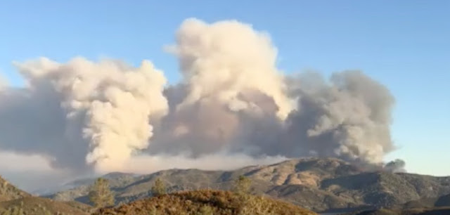
- The city of Mariposa placed under evacuation orders for it's 20,000 residents as the Detwiler Fire crept closer and continued to roar out of control
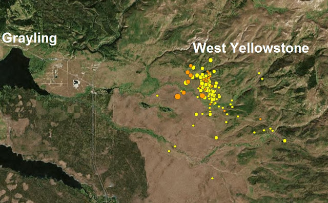
- A mag 3.6 strikes West Yellowstone bringing the current sequence to more than 1200 since June12th
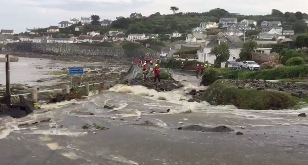
- 100,000 lightning bolts:1 months rain in 2 hours and a 4ft wall of water which ripped up roads as English village is turned into an "apocalypse"
| The city of Mariposa placed under evacuation orders for it's 20,000 residents as the Detwiler Fire crept closer and continued to roar out of control Posted: 19 Jul 2017 01:16 AM PDT Photo wildfiretoday.com The city of Mariposa was placed under evacuation orders for it's 20,000 residents shortly after noon Tuesday as the Detwiler Fire crept closer and continued to roar out of control as it burned towards the town from Lake McClure. The Mariposa County Sheriff's Office called all available units back to key parts of the main town area shortly before noon to prepare residents for evacuation. Firefighters, however, faced difficulties obtaining resources throughout the day as Cal Fire and other agencies battled at least a dozen active blazes across the state. At noon, evacuations were ordered along Highway 49 north from Agua Fria Road to Highway 140, in the center of Mariposa, along with all feeder roads. At least nine hotels in that area were evacuated. Joan Balarge was one of the first to experience the effects as ash rained from the sky. When she arrived to Mariposa Shipping Company to ship a package, she saw the shop, and nearly all other businesses on Mariposa's main street, were already closed. "It's so darn dry now, it's really terrifying," said Balarge, who lives between Mariposa and Oakhurst on Triangle Road. "I've lived through these very recently and every time it's just scary. I really hope they get this under control." But only a few short hours later, evacuations had been ordered in the Ben Hur, Agua Fria, Mount Bullion, Guadalupe Mountain, and Yaqui Gulch areas of Mariposa County as the inferno continued to spread its uncontrolled wrath towards the southeast. Highway 49 was closed north of Mariposa at the Highway 140 junction up to Highway 132 in Coulterville. Highway 140 was closed from that point to nine miles east of the Mariposa/Merced county border. Additional closures along both highways were put in place in all affected evacuation areas, as well as any interior roadways. By Tuesday afternoon, the fire had claimed 19,600 acres and was 5% contained as more than 780 firefighters worked to try and control the raging blaze. Several power outages were reported, with at least one still in effect by 7:30 p.m. in the Bear Valley area directly east of Lake McClure. Power lines that serve Yosemite National Park were also affected. Early Tuesday morning, the fire was estimated to cover 15,500 acres. In the latest update at 6:30 p.m. Tuesday, at least one structure was damaged, and another destroyed, but some Cal Fire officials estimated those numbers may rise. The Red Cross moved an evacuation shelter from a Mariposa location to Caesar Chavez Junior High at 161 S. Plainsburg Road in Planada. Two more shelters were set up in Oakhurst - at the Evangelical Free Church, 50443 School Road (427), and the Sierra Vista Presbyterian Church, 39696 Highway 41. Home |
| A mag 3.6 strikes West Yellowstone bringing the current sequence to more than 1200 since June12th Posted: 19 Jul 2017 12:49 AM PDT USGS The University of Utah Seismograph Stations reports that a minor earthquake of magnitude 3.6 occurred at 02:31 PM on July 18, 2017. (MDT) The epicenter of the shock was located 9.3 mi N of W. Yellowstone, MT.This earthquake is part of an ongoing sequence of earthquakes that began on June 12, 2017 and included a magnitude 4.4 event on June 15, 2017, 9.0 mi NNE of W. Yellowstone, MT. Today's M 3.6 earthquake was reported felt in Yellowstone National Park and in West Yellowstone, MT. It was followed by numerous smaller earthquakes, the largest of which had magnitudes of 2.8 and 2.9. The total number of located earthquakes in the current sequence has now exceeded 1200. Last month The University of Utah Seismograph Stations reported that an earthquake of magnitude 4.5 occurred at 06:48 PM on June 15, 2017 (MDT). The epicenter of the shock was located in Yellowstone National Park, eight miles north-northeast of the town of West Yellowstone, Montana. The earthquake was reported felt in the towns of West Yellowstone and Gardiner, Montana, in Yellowstone National Park, and elsewhere in the surrounding region. It was part of an energetic sequence of nearly 500 small to medium earthquakes in the same area that began on June 12, see map below. The mag 4.5 earthquake was the largest earthquake to occur in Yellowstone National Park since March 30, 2014, when a magnitude 4.8 event occurred 18 miles to the east, near Norris Geyser Basin. Home |
| 100,000 lightning bolts:1 months rain in 2 hours and a 4ft wall of water which ripped up roads as English village is turned into an "apocalypse" Posted: 18 Jul 2017 11:22 PM PDT Photo howldb.com
Incredible amounts of rain, a months total in just a couple of hours causes a 4ft wall of water which ripped up roads and damaged 50 homes after freak thunderstorms strike along with more than a thousand lightning strikes hit a sleepy Cornwall village in the UK. Lightning storms have lashed the south-east of England, hours after a village in Cornwall was cut off by flash floods. A yellow weather warning was put in place for London and the south east, as forecasters warned of "frequent lightning". "Thunderstorms are moving towards the London area. Intense rain, gusty winds, hail and frequent lightning all possible," the Met Office tweeted in the evening. As the storm rolled in, the lightning strikes were soon trending on Twitter as users, including comedian Bill Bailey, shared dramatic images of the storm. Earlier in the day, the severe weather had battered the south-west of the country. Fire crews raced to the small Cornish seaside town of Coverack amid "multiple reports of flooding" as ferocious thunderstorms moved over the area. Locals said say flash floods from "torrential downpours" in the storms had swamped homes and shops, while market stalls had been "swept away". Cornwall Fire and Rescue Service said its crews were attending "multiple flooding-related incidents" in the Coverack area. amid reports people were in "life-threatening situations" with all roads into the town, many on steep cliff inclines, deluged with water. It was also reported that a couple in their seventies were airlifted from their home as the flash floods hit. Residents described the scene as like an "apocalypse" and compared it to the devastation in Boscastle several years ago. Dozens of lightning strikes were captured on camera as hail and torrential rain battered parts of the West country late on Tuesday as summer was rudely interrupted. At Nare on the south Cornwall coast, 50mm of rain fell in an hour and there were 32 knots of gusting winds. Reports suggested some people were trapped in flooded homes and vehicles may have been swept off the road by the torrential rain. Wendy Davies, who lives in Coverack, said her garden was destroyed but feared many others had lost everything and described it as a scene out of a disaster movie. Police appealed to people not to approach the area. A Met Office spokesman said that by 7.30pm, the worst of the weather had already passed over Cornwall and moved over the Irish Sea. Hampshire was also experiencing some heavy storms on Tuesday evening, some of which were likely to affect parts of Wales. The spokesman said the storms would pass over quite quickly. "In Cornwall, the steepness of the area and the hills has enhanced the impact," he added. The Met Office issued a yellow, severe weather alert that was due to last from 4pm until just before midnight, warning there could be localised flooding. The thundery conditions are expected to move north overnight and the weather warning transfers to large swathes of the country north of the M4 on Wednesday. The Met Office said "Thundery showers are expected to push north across southern parts of the UK through Tuesday evening, perhaps turning more widespread towards midnight. "Although many places won't see these showers, there is a chance of localised flooding of homes, businesses and susceptible roads." xx xx Home |


» utube MM&C 4/26/24 Iraqi Dinar - US Treasury Exchange Rates- Focus - Banking Partnerships - Rate C
» Parliamentary efforts to transform Iraq into a global market for transferring Internet capacities
» A parliamentary committee that enriches the political forces: Stop plundering Iraq’s wealth and work
» Politician: Salem Al-Issawi is the most likely to assume the presidency of Parliament
» The price of the dollar is close to 145 thousand dinars؛ how much is $100 worth of transactions؟
» Al-Sudani: The world today is witnessing crises whose impact has been reflected in the global econo
» The Federal Court responds to an inquiry by Al-Sudani regarding the powers of the provincial council
» Among them are the Iraqis... a list of the most sought-after immigrants to America
» An expert talks about the "biggest barrier" and the positives of merging Iraqi and Arab banks
» The House of Representatives adjourns its session
» Parliamentary demands to expedite the legislation of the Eid al-Ghadir holiday law (documents)
» Parliament adds the paragraph “Electing the Speaker of the House of Representatives” to its agenda
» Alsumaria publishes the text of the law against prostitution and homosexuality
» A parliamentarian reveals the reason for the failure of the Speaker of Parliament to pass during tod
» Al-Sudani: The government has launched many strategies and initiatives that will improve the reality
» International Business: Iraq has made progress in supporting businesses through investment and priva
» Association of Banks: Iraq is witnessing great development in the transition to electronic governmen
» The House of Representatives votes to add an item to its agenda (election of the Speaker of the Hous
» Parliamentary integrity: Combating corruption requires parliamentary legislation
» Al-Karaawi: America is trying to restrict Iraq
» The State of Law coalition moves to form the local government in Diyala
» The Sudanese and his battle against corruption.. Where is the fault with the government or with the
» Prime Minister's Advisor: We will see the dollar fall on the black market soon
» The Sunni blocs are resolute. The presidency of the Council is ours, away from Al-Halbousi
» Al-Sudani discusses with a workers’ organization his government’s steps in this field
» Parliament holds its session in the presence of 170 deputies
» In the presence of Nechirvan Barzani and Al-Sudani... the State Administration Coalition holds an “i
» The UAE company ADNOC resorts to Iraqi oil. Find out the reasons
» The Iraqi Parliament votes to add an item to elect a president to its agenda
» The Federal Court responds to an inquiry by Al-Sudani regarding the powers of the provincial council
» Al-Sudani: It is necessary to attract women to work as a productive energy that cannot be disrupted
» Zebari regarding targeting the Kormor field: a systematic attack on the economy of Kurdistan
» Saudi Arabia tops, and this is Iraq's rank... a list of major suppliers of crude oil to South Korea
» With a value of 125 million dollars.. Iraq is at the forefront of countries importing Iranian textil
» More than a billion dollars in sales from the Iraqi Central Bank within a week
» Al-Sudani stresses the need for the expertise of the International Labor Organization to legislate a
» Including the return of 21 wanted persons.. The Iraq Money Recovery Fund counts its achievements in
» The path to development is the criterion between true patriotism and political clowning.
» The file of the Presidency of Parliament is on the state administration table... this evening
» Director General of the International Labor Organization: Many challenges in the world of work and t
» Al-Sudani: The world is witnessing crises that reflect negatively on the Arab and international peop
» Prime Minister: Our government has provided great support for the success of the activities, program
» Al-Asadi: Iraq places the social protection file among its priorities
» Al-Sudani: Iraq is one of the first countries in the region to join the International Labor Organiza
» In the presence of Al-Sudani and Barzani, the State Administration Coalition holds an “important” me
» Appreciating the presence of Al-Sudani... Director General of the Arab Labor Organization: Here from
» Prime Minister: Our government has provided great support for the success of the activities, program
» Al-Sudani: The world is witnessing crises that reflect negatively on the Arab and international peop
» The Parliamentary Development Institute organizes a workshop on the political role of the representa
» With Arab and international participation. Tomorrow will be the start of the Fourth Baghdad Internat
» OPEC Secretary General: The end of oil is not on the horizon
» Closing a number of unlicensed offices and companies south of Baghdad
» Repercussions of the bombing...intensive government movements to resume work in the “Kormor” field
» In the presence of Al-Sudani...the opening of the Arab Labor Conference in its 50th session in Baghd
» Al-Sudani: We are working on drawing future visions regarding the “green and digital” economic secto
» Barzani after the Kormor attack: We are ready to coordinate with Baghdad to put an end to these atta
» Al-Sudani directs the formation of an investigative committee into the circumstances of the Kormo fi
» Bismayah is confused about the new electronic portal.. What about the landlord and the subcontracts?
» Kurdistan Government: Loss of 2,500 megawatts of electricity due to targeting the Kormor field
» Crisis in Kurdistan: 12-hour daily power outage and complaints of “confusion”
» The Supreme Anti-Corruption Commission demands Nineveh for the contracts concluded by “Najm Al-Jubou
» Al-Khanjar, Al-Samarrai, and Abu Mazen are hosted by Shaalan Al-Karim to discuss accelerating the se
» Iraq asks the countries of the world to respond to its requests to extradite wanted persons: We have
» “It is coming soon.” The Sudanese advisor sets the date for the referral of the Baghdad metro and th
» Al-Mubarqa: Iraq reserves its full right to respond to the Australian behavior
» Dollar exchange rates on Iraqi stock exchanges... recorded a decline, and this is the list
» Mr. Al-Sadr supports the position of American university students
» Iraqis are ranked 7th in the Arab world on the list of those most seeking immigration to America. He
» Soon.. 3 new hospitals will open in Baghdad
» Sponsored by Al-Sudani...the opening of the Arab Labor Conference in its fiftieth session in Baghdad
» Al-Shammari chairs a meeting at the controlling headquarters to review the results of the security o
» Arab Labor Organization: We commend Iraq's interest in the Arab Labor Conference
» Al-Sudani: The development road project will provide many job opportunities
» Sudanese advisor criticizes Kuwaiti analyzes regarding the development road project
» Al-Mandalawi stresses the need to strengthen economic and trade cooperation between Iraq and Poland
» Power maneuvers: America provides defensive weapons to Kurdistan in exchange for withholding from Ba
» Kuwait is drilling an oil well near Umm Qasr, towards Iraqi territory
» In the document... the first Iraqi ministry identifies the obstacles to changing the new official wo
» Italian Institute: Iraq is stuck in its own crises, including Baghdad’s efforts to undermine the “au
» The head of the Integrity Commission announces the holding of an international Interpol conference i
» Planning: Iraqi companies are not efficient in conducting the population census
» MM&C 4/25/24 National Bank of Iraq goes live with Temenos core banking and payments
» A banking official indicates a "danger" to Iraq by depriving more than half of its banks of dollars
» With the participation of the Association of Private Banks, investment opportunities are on the tabl
» Within a month... an Iranian border crossing recorded a noticeable increase in exports of goods to I
» The Association of Private Banks appreciates the efforts of the government and the Central Bank to c
» Al-Maliki's coalition presents a third candidate for the position of governor of Diyala
» Arab gathering: The Kirkuk problem is getting complicated and the Sudanese must intervene
» Next week.. a Kurdish delegation will visit Baghdad to meet with the Minister of Finance
» Under the pretext of salaries... Al-Party refrains from handing over port revenues to Baghdad
» Association of Banks: For the first time, we are witnessing a clear targeting of depriving half of t
» Parliament does not know the reason for the delay in sending the 2024 budget schedules: Voting takes
» Applicants for the 2024 Hajj are demanding that the Central Bank secure the dollar for them through
» Governmental and private banks will showcase their services tomorrow during Financial Inclusion Week
» Iraq's oil exports rise despite OPEC+ cuts
» A study explodes a "surprise"... Iraq is among the countries that export oil to "Israel": How is the
» Al-Araji emphasizes working to strengthen national identity
» Al-Sudani visits Saudi Arabia to participate in the World Economic Forum in Riyadh